Zoning & Maps
ZONING
The purpose zoning is to promote the public health, safety and general welfare of existing and future residents of the city of Spring Valley by:
(A) Implementing the comprehensive plan;
(B) Classifying land within the city into zoning districts;
(C) Regulating the location and use of all structures, lands and waters;
(D) Regulating the intensity of uses and structures through building coverage, density and dimensional standards;
(E) Ensuring protection from fire, flood and other dangers;
(F) Lessening congestion and promoting the safety and efficiency of streets and highways;
(G) Improving pedestrian safety;
(H) Providing adequate privacy, light, air, sanitation, and drainage;
(I) Preventing overcrowding and avoiding undue population concentration;
(J) Facilitating the adequate provision of public facilities and utilities;
(K) Providing adequate and aesthetically pleasing stormwater management facilities;
(L) Stabilizing and protecting property values;
(M) Furthering the appropriate use of land and conservation of natural resources;
(N) Maintaining and enhancing the aesthetic appearance and physical design of the city;
(O) Encouraging the effective use of signs as a means of communication for businesses, organizations and individuals, and minimizing the possible adverse effects of signs on nearby public and private property;
(P) Ensuring sound development and community growth by establishing minimum standards for subdivision design;
(Q) Promoting aesthetically pleasing development by establishing minimum standards for installation of landscaping and screening materials;
(R) Minimizing the adverse impacts of noise, dust, glare and other objectionable activities or impacts;
(S) Promoting the development of land for the highest possible use and protecting against deterioration and obsolescence that would adversely affect the living environment or tax base;
(T) Providing common grounds of understanding and a sound working relationship between the city and developers and to safeguard the interests of the homeowner, the subdivider, the investor and the city;
(U) Managing growth within the city by concentrating development within the effective operating range of existing public utilities and improvements;
(V) Causing the cost of design and installation of improvements in new, platted subdivisions to be borne by the persons purchasing the lots rather than by any direct or indirect burden upon existing property owners beyond the limits of the subdivision;
(W) Coordinating new subdivision design with the design of the city as a whole to allow for the proper capacity of all types of improvements on the basis of an orderly sequence of subdivisions as a part of neighborhoods and neighborhoods as a part of the community;
(X) Securing the rights of the public with respect to public lands and waters;
(Y) Improving land records by establishing standards for surveys and plats; and
(Z) Providing for the administration and enforcement of this title and providing penalties for its violation
Latest Zoning Documents
-
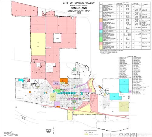
Zoning Map
March 21, 2022
1 attachment
-
Zoning Change Application and Process
March 21, 2022
1 attachment
-
Variance Permit
March 21, 2022
1 attachment
-
Spring Valley Street Map
March 21, 2022
1 attachment
-
Special Use Permit
March 21, 2022
1 attachment
-
Special Use Application
March 21, 2022
1 attachment
-
Petition for a Change in Zoning
March 21, 2022
1 attachment